


Description
SW Road is the complete package for road design that is efficient, powerful, accurate and convenient. Since 1993, the software has evolved significantly with feedback from numerous projects and users. The current version of SW Road include multicore parallel processing, better graphics, and higher computation speed, designing of multilane roads, multialignment, handling of background imageries, 3D view and road animation and cost estimation
Interactive Design Environment
SW Road V2 has a standalone interactive design environment which is easy to use and familiar to CAD users
Built-in Digital Terrain Modelling
The SW Road V2 has built in power full DTM with unlimited points capability. The DTM is seamlessly integrated and can be used for extraction of Longitudinal and Cross Section Profiles as well as 3D Visualization
Powerful Cross-Section Editor
SW Road V2 includes a power cross-section editor with many options for structures, drains, walls and more in a very convenient design environment
Drawing Generation and Sheet Planning
Provides production of the final drawings with sheet planning directly in the DXF format which can be handled by many CAD application
Automated Quantity Abstraction
The quantity are automatically extracted from the cross-section for various types of works eg cut, fill, structure cut, structure volume etc. Quantities can be extracted for any given range of changes. A mass haul diagram is also integrated for earthwork to plan soil tips etc
Complex Design of Hill Roads
Option like checking for center line shifts, optimization of the structures, editing of the parameters for extra widening and super elevation, drainage design provide a powerful design environment required for the complex design of hill roads
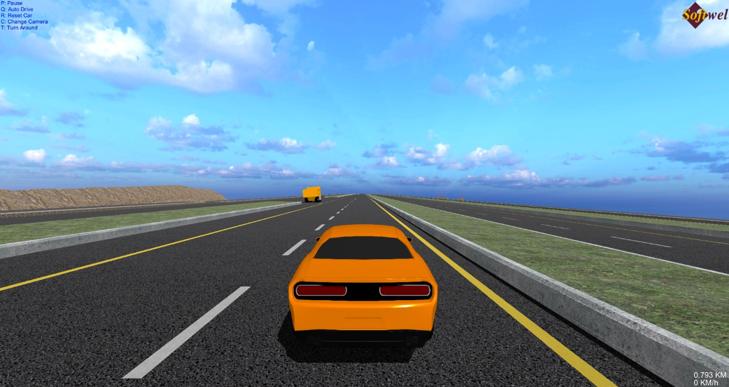
3D Visualization
3D visualization of the road project is included with interactive viewing and animation mode. The 3D visualization provides the detailing of the walls, location of culverts, cutfill lines in complete rendered visual way.
Staking
The staking module is capable of providing information in the plan with all the types of the structures, cut-fill lines and more. This information is can be effectively used in land acquisition temporary by pass and storage planning works
Extra widening and super-elevation editing
Quickly edit the extra widening and super elevation parameters and have the changes readily updated in the plan and cross section
Pass Bys, Bus Bays, Acceleration-Deceleration Lanes, Variable Road Width
Dedicated tools for adding and editing pass-Bys, Bus Bays, Acceleration-Deceleration Lanes as well as variable road widths give the designer complete control over the complex design of roads.
Different types of horizontal curves
It can generate output with complete information of circular, circular and spiral combination or completely spiral curve elements of horizontal curves with in no time.
